

Participate in Wiki Loves Earth India 2016 Photo contest
Upload Photos of Natural Heritage sites of India to help Wikipedia & win fantastic Prizes
Check out the rules here
EditWatch this page
Tikamgarh
This article is about the municipality in Madhya Pradesh, India. For its namesake district, see Tikamgarh District.
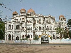
Tikamgarh Palace
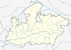

Location in Madhya Pradesh, IndiaCoordinates: 24°44′50″N 78°50′00″ECountry IndiaStateMadhya PradeshRegionBundelkhandDivisionSagarDistrictTikamgarhNamed forKrishna as TeekamGovernment • BodyMunicipality • ChairmanLaxmi-Rakesh Giri
(BJP)Area • Total21 km2 (8 sq mi)Elevation349.170 m (1,145.571 ft)Population (2011)[1] • Total79,106 • Density3,800/km2 (9,800/sq mi)Languages • OfficialHindi, Bundeli, EnglishTime zoneIST (UTC+5:30)PIN472001 (HPO)Telephone code91 7683Vehicle registrationMP-36Coastline0 kilometres (0 mi)Sex ratio0.911[2] ♂/♀Literacy85.02%[3]Distance from New Delhi500 kilometres (310 mi) N (land)Websitetikamgarh.nic.in
Tikamgarh ( टीकमगढ़ ) is a town and a tehsil inTikamgarh district in the Indian state of Madhya Pradesh.[4] The city serves as a district headquarters. The earlier name of Tikamgarh was 'Tehri' (i.e., a triangle) consisting of three hamlets, forming a rough triangle. In Tikamgarh town there is locality still known as 'Purani Tehri' (Old Tehri). Until Indian independence in 1947, Tikamgarh, formerly called Tehri, was part of the kingdom ofOrchha, which was founded in the 16th century by the Bundeli chief Rudra Pratap Singh, who became the first King of Orchha. In 1783 the capital of the state was moved to Tehri, about 40 miles south of Orchha, which was home to the fort of Tikamgarh, and the town eventually took the name of the fort. The district is famous for the old fort of Kundar known as Garh Kundar, which was built byKhangars and remained the capital of kshatriya Khangar rulers from 1180 to 1347.
Origin of the nameEdit
The district is named after its headquarters, Tikamgarh. The original name of the town was Tehri. In 1783, the ruler of Orchha Vikramajit (1776–1817) shifted his capital from Orchha to Tehri and renamed it Tikamgarh (Tikam is one of the names of Krishna).[5]
HistoryEdit
The area covered by this district was part of thePrincely State of Orchha till its merger with theIndian Union. The Orchha state was founded by Rudra Pratap in 1501. After merger, it became one of the eight districts of Vindhya Pradesh state in 1948. Following the reorganization of states on 1 November 1956 it became a district of the newly carved Madhya Pradesh
Orchha was founded in the 1501 AD,[6] by theBundela chief, Rudra Pratap Singh, who became the first King of Orchha, (r. 1501-1531) and also built the Fort of Orchha.[7] He died in an attempt to save a cow from a lion. The Chaturbhuj Templewas built, during the time of Akbar, by the Queen of Orchha,[8] while Raj Mandir was built by 'Madhukar Shah ju Dev' during his reign, 1554 to 1591.[9][10]
During the rule of Mughal Emperor, Jahangir, his ally, Vir Singh Deo (r. 1605-1627) reigned here, and it was during this period that Orchha reaches its height, and many extant palaces are a reminder of its architectural glory, including Jahangir Mahal (b. ca 1605) and Sawan Bhadon.[11]
In the early 17th century, Jhujhar Singh rebelled the Mughal emperor Shah Jahan, whose armies devastated the state and occupied Orchha from 1635 to 1641. Orchha and Datia were the only Bundela states not subjugated by the Marathas in the 18th century. The town of Tehri, now Tikamgarh, about 52 miles (84 km) south of Orchha, became the capital of Orchha state in 1783, and is now the district town; Tehri was the site of the fort of Tikamgarh, and the town eventually took the name of the fort.[12]

Flag of princely state of Orchha, Tikamgarh
Hamir Singh, who ruled from 1848 to 1874, was elevated to the style of Maharaja in 1865. Maharaja Pratap Singh ju Dev (born 1854, died 1930), who succeeded to the throne in 1874, devoted himself entirely to the development of his state, himself designing most of the engineering and irrigation works that were executed during his reign. In 1901, the state had an area of 2,000 sq mi (5,200 km2), and population of 52,634. It was the oldest and highest in rank of all the Bundela states, with a 17-gun salute, and its Maharajas bore the hereditary title of First of the Prince ofBundelkhand. Vir Singh, Pratap Singh's successor, merged his state with the Union of India on January 1, 1950. The district became part ofVindhya Pradesh state, which was merged intoMadhya Pradesh state in 1956. Today Orchha is almost a nondescript town with a small population, and its importance is maintained only due to its rich architectural heritage and tourism.
General informationEdit
As of 2011 India census, Tikamgarh has a population of 79,106. It has an average literacy rate of 85.02%, higher than the state average of 69.32%: male literacy is 89.98%, and female literacy is 79.59%. In Tikamgarh, 11.85% of the population is under six years old.[13]
Hospital facilitiesEdit
Rajendra District HospitalRai Surgical HospitalGovind Sai Maternity HomeMatratwya Nursing HomeSeva Nursing HomeShriram Nursing HomeLife line Nursing HomeSudha Sevalaya Nursing Home
DemographiesEdit
Tikamgarh is a city in the central Indian state ofMadhya Pradesh. It is the administrative headquarters of Tikamgarh District. It is nearby to the border of U.P. Tikamgarh, situated towards the west to the centre of plateau of Bundelkhand is surrounded by district Jhansi of UP in the north and Lalitpur (UP) in the west and south. Towards its east, district Chattarpur is situated.
Tikamgarh has a population of 79,106 divided into 27 wards. Schedule Caste (SC) and Schedule Tribe (ST) constitutes 14.89% and 1.80% of the total population. Based on the latest census 2011, 69.95% of the total population are Hindus, 20.87% are Muslims, 8.77% are Jains and the rest is occupied by Christian, Sikh and Buddhist.[14]
TransportationEdit
RoadsEdit

Welcome gate at Jhansi Road in Tikamgarh

Half view Of Bus Stand (Tikamgarh)
About 20,000 of vehicles are running on Tikamgarh city roads including light and heavy vehicles.There are daily service of buses for every part of state.Highways Passing from Tikamgarh Are, NH-12A, SH-37, SH-10.Dr. Syama Prasad Mookerjee Bus Stand Daily service of Buses for New Delhi, Lalitpur, Nagpur,Kanpur, Indore, Bhopal, Jhansi, Gwalior, Jabalpurare also there.
RailwaysEdit

Tikamgarh Railway Station
The construction of railway line to Tikamgarh has been completed in 2012.On 26 April 2013 was connected with railway services. The rail services begun from Lalitpur (Uttar Pradesh) to Tikamgarh and was started under the Lalitpur-Singrauli Rail Project.The first train to travel between the two stations was Tikamgarh-Jhansi (Uttar Pradesh) passenger train. The train was sanctioned between the two stations in the Rail Budget of 2012-13. The railway line between Tikamgarh and Lalitpur rail route is 52 kilometer long. Union Minister Pradeep Jain flagged off the train at Lalitpur station
AirwaysEdit
Khajuraho is the nearest (125 km) airport from where daily flights operate for Delhi & Agra.
GeographyEdit
The city has natural beauty with many parks & lakes which surround the city from every direction.

.jpg)
A view of Mahendra Sagar in Tikamgarh
Mahendra Sagar (Bada Talab).Sail Sagar.Vrandavan Talab (Jhir ki Baghiya).HanumanSagar Talab.Maharajpura Tal.
a Park (Central Park) inaugurated by Dr. Rajendra Prasad First President of India
Nazarbaugh Garden (Only for ladies)UpVan park (Jhirki Baghiya)Shaan-E-Park TKGChandra Shekhar Ajad ParkChildren Park Civil LineSubhash Chandra Bose ParkMoniya Party Crossing
Games and sportsEdit
The Sports Authority of India (SAI) has its training centre & hostel situated here, facilitating Hockey & Softball.
All India Veer Singh Ju Dev Hockey TournamentNoor Mohammad Memorial Football Tournament(Najarbaugh)Night Cricket Tournament (Najarbaugh)Night Basketball Tournament (Najarbaugh)
List of clubsEdit
D.H.A.Bright ClubSai Center
Places of interest
Notable people
Education
Radio and television station
Banking
See also
References
External links
Last edited 4 days ago by Abhijitsathe
 ®
®
MobileDesktopContent is available under CC BY-SA 3.0 unless otherwise noted.Terms of UsePrivacy
No comments:
Post a Comment